-->

Designing Bhubaneswar: The geographical space #Ep-3


Old town satellite map
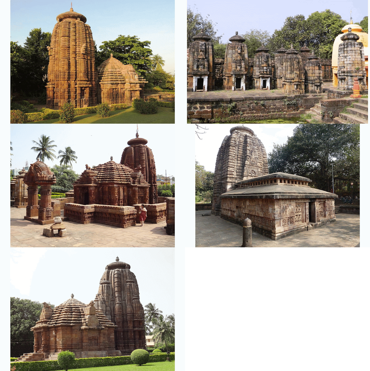
The Old Town Area: The old town area dates back to the 6th century when the biggest temple in Bhubaneswar now, i.e. The Lingaraj Temple was getting its initial shapes. During those days people mostly worshiped Lord Shiva. By the time the temple was fully constructed around the late 11th century, Lord Jagannath Sect had been growing in Kalinga which eventually evidenced the coexistence of Shiva and Vishnu at the temple. Back then it was the reign of Jajati Keshari of Keshari Dynasty who shifted the capital from Jajpur to Ekamra Kshetra (Temple city), the ancient name of Bhubaneswar.

Shiva Temples

 The name Bhubaneswar falls from the fact that, Shiva’s other name was “Tribhubaneswara” or “Bhubaneswara” and since the Ekamra Kshetra was surrounded by the temples of Shiva, it was attracting more people to gather, trade and live surrounding these temples eventually forming a town called Bhubaneswar. After independence, Jawahar Lal Nehru led the foundation and shifted the Capital of Odisha from Cuttack to Bhubaneswar around 1948.

The old town area is a congested area nowadays. The poor architecture and infrastructure literally justify its name. The narrow gullies make it hard for modern transportation to explore the area. Colonies like the Lingaraj colony, the Rajarani colony, Pandav Nagar, Brahmeshwar bagh, Bhimatangi, Gauri Nagar, etc. conglomerate to form a densely populated region enveloped in a small area.

But the historical importance of pure Kalinga architecture attracts many tourists from national and even international lands to visit this place and admire the ancient wonders of the past. Apart from Lingaraj temple, Mukteshwar temple, Rajarani temple, Parsuramesar temple, Astasambhu temple, Nageshwar temple, Megheswar temple, Yameshwar temple, Lakheswar temple and many more are the landmarks of exquisite architecture situated in this tract.

Ekamra Kshetra, the old Bhubaneswar Zone being the central part of BDPA is defined as a Socio-Cultural hub and plans are being made to preserve and restore the culturally impactful heritage of the city. The housing space is pretty congested as it was the first area to get crowded after the foundation of the city. Thus, not much planning or designing is required but the maintenance prospectus will play a vital role in the coming future.


Waterways
As per the Comprehensive Developmental Plan (CDP) 2030 for Bhubaneswar Development Plan area (BDPA), a brief report by architectural division, IIT Kgp, an attempt to revive the historical navigation is going to take place stretching from Sribantapur-Sisupal-Ekamra Kshetra. Previously the Gangua nallah was used as a mode of navigation as well as transportation (Inland Waterways) which with time and urbanization vanished. Efforts are being made under the garland lake system, one of the seven corridors proposed in the report emphasizing building a series of lakes alongside Gangua Nallah which may restore the lost historical essence.
  
The next episode will continue with the planned city (the new town area), a brief description of the geography and related conjuncts. It will be followed with possible developmental areas, some salient features included in the city developmental plan of 2030 report, geographical area at a glance. 


Share:

Designing Bhubaneswar: The geographical space#Ep-2

The Geographical space: This episode will be completely based on the new side of  Bhubaneswar, a geographical inspection of the spaces developing rapidly after the 2000s. It will also describe all the landmarks situated in this area, how they work and how they are affecting the economy and living of the place and hence calling it the developing side. This will be a new section all by itself then we will be departing to the old and heritage one. 

Bhubaneswar Map
The developing side: The NH-16 divides the whole city area approximately into two equal halves, connecting the silver city, Cuttack passing through KhandagiriBaramundaCRP SquareJaydev ViharAcharya ViharVani Vihar, and Rasulgarh checkpoints. The north side of the divided city includes two industrial estates, one is the Chandaka industrial estate and the other one is the Mancheswar Industrial Estate.

The Mancheswar industrial estate was created to have a small scale industrial hub, but it went the other way around. By the status reports from IDCO, there are 137 different industries prevailing in that zone from which more than 20 were hotels, lodging and boarding, garage, PCO booth, stationery shops, and go-downs. 64 were under construction and 35 are lying unused.

Mancheswar Industrial Estate

Still, this area is the most important spot for MSME sectors based industries in the Bhubaneswar map. Orissa RenewableEnergy Development AgencyOrissa Small Industries Corporation Ltd., PostalPrinting PressCentral Testing Laboratory are some of the prominent MSMEs residing in this estate. Most of the small-scale manufacturing and assembly units are also placed in this area making it the manufacturing hub of Bhubaneswar.

On the other hand, Chandaka Industrial Estate is the newly emerging industrial estate encompassing specialized technical & management Institutions and Training centers. It also borders the Silicon Valley of Bhubaneswar; home to many Multinational and national IT-based firms making it the industrial Estate of tomorrow.  Special Economic Zone(SEZ) developed by IDCO at Chandaka, otherwise known as Infocity has established units of InfosysWiproTCSMind Tree, etc. to cultivate IT and ITES trends within the city.


Chandaka Industrial Estate
A growing center of skill development and a recognized MSME, CTTC, Bhubaneswar is flourishing its capabilities in this area. Lighting the conventional training platform, it has trained many young minds to work in the Mechanical, Civil, Electrical, and Electronics backgrounds with specialized expertise given to them in this home-based center. CIPET, Bhubaneswar is also gearing up to its full performance and achieving greater heights in the field of plastic designing, manufacturing, and research. It will soon be positioning its flag higher within a few years by devoting its efforts to the construction of Paradeep Plastic Park, in collaboration with IDCO.


Technical Institutes, Patia 
Reputed Technical Institutions like KIIT UniversitySilicon InstituteNilachal PolytechnicCEBNIFT, and MITS is also largely adding value to this place. Management Institutes like KSOMBIITMUSBMSrusti Academy, etc. in this area aspire to put footprints globally creating professional assets and leaders of tomorrow. With quality infrastructure and supported by state of the art technology, all the institute strives to set high standards of education by continuously improving the quality and content of pedagogy. 

The Bhubaneswar Development Authority (BDA) has very precisely planned the areas of  Patia and Chandrasekharpur to rightfully accommodate the existing populace with adequate residential commercial zones(Retail & wholesale). The working class prevailing are residing in these areas gradually increasing their density. This increase in the density of outsiders has also increased the local vending zones in these areas with few formalities and in-formalities. Damana being an intersection point has been allotted with the retail commercial and business use zone for better flow of liabilities and facilities. 
Developmental Plan Area 2030

Being the plinth soil of many one-room startups in their initial phase, C.Spur and Patia area predicts a valuable future for tomorrow's world. The District center situated in Chandrasekharpur inhibits many IT-based and core-based startups trying to surpass their break-even's within a few years, building it to the best place for the nourishment of budding entrepreneurs.  


The southern parts of Chandrasekhar face the Rail Sadan attached with the railway quarters alongside the OSAP 7th Battalion and police quarters. The Northside of Rail Sadan faces the OMFED factory making it a small industrial zone distributing dairy products with ease of transportation and coverage.

Fortune Tower is another IT Specific project by IDCO which is situated at a distance of 4.0 Kms from the Chandaka Industrial Estate. It was one of the first IT parks to be constructed at a prime location in this developing side. Right next to it is the Tech Mahindra Campus, which also provides IT and BPO related jobs to the techies in Bhubaneswar. Educational Towers like XIMB, Regional College of Management, ELTI, and NIOS circumscribe the Fortune towers bringing bags of fortune to this area.

This blog will continue describing the developing side in the future Section The Developing side: At a glance. The next episode will include Part:2 of the geographical space tour which will narrate the Old Town and New town Areas of Bhubaneswar. 


Share:

Designing Bhubaneswar: Introduction #Ep-1


During old times temples were the hub of gathering knowledge and intellect. Scholars and pioneers used to visit temples to enrich their scope and perspective, in return shared their brains to the eager minds of today. Bhubaneswar, the city with the most number of temples aptly named as the temple city is a home to very recognized stalwarts in every field. It is also elected as the top-ranked in the list of smart cities of India. Best for investments and trades, it is luring many multinational giants as well as skilled personnel with expertise in different sectors to settle in its soil.

Since it is one of the first models of planned cities during the independence riots, it holds a huge potential in terms of resources, geographical plots, roadways, centers of excellence, even market distribution, exemplary infrastructures, and outlying industrial areas. Emerging entrepreneurship environment and budding start-ups will change it to a beacon of developed cities within a few years.


Thus, to look out for a brighter vision, we need to plan it more precisely and it can be only done by brainstorming, analyzing, designing and implementing all changing the aspects practically for the use. The enthusiasm of youth circle along with experiences of the older generation can contribute positively to its cause.

But with pure development comes some debris too. We all need to take care of that simultaneously. Efficient urban planning and development, proper distribution of market and vending zones, matching transport facilities with no traffic issues, proper waste management practices, disaster management schemes(pro and post), good health and sanitation, population reduction, individual  identification and information, crime reducing cells, cyber cells, online services, distributed water and electricity services, renewable energy building initiatives, pollution control, afforestation in design etc. , all of these steps need to be taken care of with equal importance to minimize the debris.

In this blog, I will go through all of these points to redesign Bhubaneswar in the best way possible. It will be an elaborate and informative approach based on certain references and assumptions. It can be backed with simulation and survey reports for value-added information. Subsequently, it can be referred by Governing bodies and authorities for practical implications.

This will be a series of blogs with an emphasis on each topic divided into different chapters. I will look over, analyze the problems and will have some solutions regarding the current scenario along with admiration to the existing landmarks.

Continued...

Stay tuned
Jay Jagannath


Share:

Popular Posts

Recent Posts